This project is sourced from another site, not written by us — this list is our best match of their components against what we stock, not a verified bill of materials. Always check the original blog (linked above) for the actual parts list before buying.
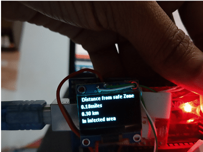
The Fencing System and Contact Traceability System is built around an Arduino Uno micro-controller that coordinates location tracking and wireless communication. At the heart of the positioning system is the NEO-GPS module, which constantly communicates with overhead satellites to determine the device's precise geographical coordinates, including latitude and longitude. The Arduino reads this positional data and compares it against pre-programmed boundary coordinates representing a designated quarantine zone or restricted area. If the Arduino detects that the current GPS coordinates fall outside of this permitted boundary, it triggers a response through the connected SIM800L GSM module. Using a standard 2G SIM card, the GSM module acts as a cellular transmitter capable of sending SMS text messages or alerts to authorities or designated contacts, thereby reporting a boundary violation. Simultaneously, the system utilizes an SSD1306 OLED display, connected via I2C communication, to provide real-time visual feedback to the user. This small screen can show current status messages, GPS fix status, and warning notifications directly on the device. Power is supplied to the entire circuit through an adequate power supply to ensure both the microcontroller and the power-hungry cellular module operate reliably. The entire logic is programmed using the Arduino IDE, relying on specialized software libraries to seamlessly handle GPS sentence parsing, OLED graphics rendering, and AT-command communication with the GSM module.
Why Build This
Learn how to integrate GPS positioning and cellular communication technologies for public health and safety tracking.
Understand the fundamentals of geofencing and how microcontrollers can enforce virtual geographic boundaries.
Gain practical experience building a complete IoT prototype using an Arduino Uno, displays, and wireless modules.
Real-World Application
Pandemic management, public health safety, quarantine monitoring, and contact tracing.
Skills You'll Learn
GPS data parsing
I2C communication
serial UART communication
cellular AT command handling
display rendering
conditional boundary logic
Safety Precautions
No specific precautions noted for this build — always follow general electronics safety practices.
Technology Tags
GPS
GSM
SIM800L
NEOGPS
SSD1306
OLED
GEOFENCING
CONTACT TRACING
ARDUINO IDE
Frequently Asked Questions
The SIM800L module can draw significant current spikes during cellular network transmission, which often exceeds the current output capacity of the Arduino's onboard 5V regulator and can cause the system to reset.
GPS modules typically require a clear line of sight to the sky to receive signals from satellites, meaning they may not acquire a position fix reliably while indoors or in heavily obstructed areas.
The SIM800L operates on 2G networks, so you will need a compatible 2G micro-SIM card and an active cellular plan that supports text messaging.
Gallery
This page is part of Kitkraft's Project Hub — a curated collection of electronics & robotics projects gathered from the maker community to help students and hobbyists discover and learn to build. Kitkraft does not claim authorship of the original project, and makes no representation as to the accuracy, completeness or safety of third-party source material. The summary and "How It Works" explanation above are AI-generated, rewritten with reference to the original tutorial — not a reproduction of it. Full credit and a direct link to the original source are provided above. If you're the original creator and have a concern about how your work is represented here, please contact us and we'll address it promptly.
 0.96 Inch I2C/IIC 4pin OLED Display Module White
Rs. 349.00
 Jumper Wire 10 Pin Male To Male 20cm
Rs. 45.00
 MB102 Adjustable Breadboard Power Supply Module (3.3V & 5V) for Arduino & Raspberry Pi
Rs. 139.00
 400 Points Mini Solderless Prototype PCB Breadboard High Quality
Rs. 89.00
 Jumper Wire 10 Pin Male To Female 20cm
Rs. 45.00


