A smart GPS geofencing system that monitors location via a NEO-6M GPS module and alerts users through an SMS message and a buzzer if a set distance threshold from a base location is crossed.
This project is sourced from another site, not written by us — this list is our best match of their components against what we stock, not a verified bill of materials. Always check the original blog (linked above) for the actual parts list before buying.
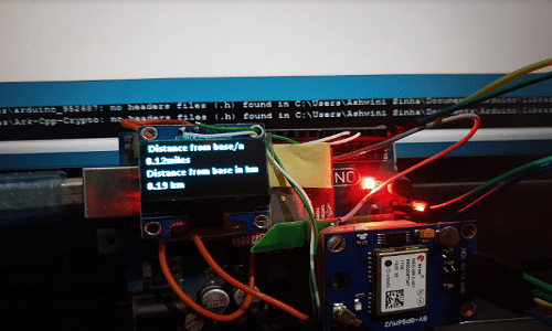
The Smart GPS Geofencing System operates by continuously tracking geographical coordinates and comparing them against a pre-defined reference location stored in the Arduino Uno. At the heart of the system, the NEO-6M GPS module receives signals from visible satellites and outputs NMEA data streams containing real-time latitude, longitude, and time information. The Arduino processes these incoming NMEA strings to extract the current positional coordinates. Simultaneously, the I2C OLED display provides local, real-time visual feedback by rendering the current coordinates and system status on screen. The system calculates the distance between the current GPS coordinates and the permitted base location using standard distance formula algorithms. If the calculated distance exceeds the configured threshold boundary, the system triggers two distinct alert mechanisms: an active buzzer sounds locally to immediately notify anyone nearby, and the SIM800L GSM module establishes a cellular connection to transmit an SMS text message notification to a pre-programmed mobile phone number. Power management across the Arduino board, GPS, GSM, display, and buzzer ensures stable operation during continuous tracking and cellular transmission phases.
Why Build This
Develop practical undergraduate-level systems engineering experience by integrating cellular communication, satellite positioning, and visual display protocols onto a single microcontroller platform.
Implement real-world spatial tracking algorithms suitable for precision agriculture applications, such as monitoring livestock boundaries or tracking valuable farm equipment across a designated perimeter.
Gain hands-on experience in remote IoT telemetry by programming automated SMS alert triggers based on threshold boundary conditions.
Real-World Application
Car tracking, parcel location tracking, livestock monitoring, prisoner or house-arrest monitoring, protection of valuable items, child monitoring, and rental car security.
Skills You'll Learn
GPS NMEA data parsing
I2C bus communication
cellular AT command handling
distance calculation algorithms
digital threshold logic
Safety Precautions
No specific precautions noted for this build — always follow general electronics safety practices.
Technology Tags
GPS
GSM
SIM800L
NEO-6M
OLED DISPLAY
GEOFENCING
ARDUINO
C++
Frequently Asked Questions
GPS receivers require a clear line-of-sight to multiple overhead satellites to calculate position. Signals struggle to penetrate building materials, so initial satellite acquisition must be performed outdoors or near a window.
No. The SIM800L module draws high current spikes during cellular transmission that exceed the current capacity of the Arduino's onboard voltage regulator, which can cause the system to reset or brown out. A separate, stable power supply capable of delivering adequate current is required.
The base coordinates are typically hardcoded into the Arduino sketch during the programming phase by recording the starting GPS position, or configured to capture the initial position upon system startup.
Gallery
This page is part of Kitkraft's Project Hub — a curated collection of electronics & robotics projects gathered from the maker community to help students and hobbyists discover and learn to build. Kitkraft does not claim authorship of the original project, and makes no representation as to the accuracy, completeness or safety of third-party source material. The summary and "How It Works" explanation above are AI-generated, rewritten with reference to the original tutorial — not a reproduction of it. Full credit and a direct link to the original source are provided above. If you're the original creator and have a concern about how your work is represented here, please contact us and we'll address it promptly.
 0.96 Inch I2C/IIC 4pin OLED Display Module White
Rs. 349.00
 Piezo Buzzer (Big) 6-12V
Rs. 45.00
 Jumper Wire 10 Pin Male To Male 20cm
Rs. 45.00
 MB102 Adjustable Breadboard Power Supply Module (3.3V & 5V) for Arduino & Raspberry Pi
Rs. 139.00
 400 Points Mini Solderless Prototype PCB Breadboard High Quality
Rs. 89.00
 Jumper Wire 10 Pin Male To Female 20cm
Rs. 45.00


